The natural environment, such as the geographic and climatic features of Japan’s northernmost island of Hokkaido differ greatly to those of Honshu and southern Japan. The fauna and flora have devised a variety of ways to endure the extreme cold, resulting in the existence of many endemic species unique to Hokkaido. The natural surroundings the wildlife inhabits – the scale of the land and sea with which one can sense the structure of the Earth – is also one of Hokkaido’s greatest charms.
Plant life found in Hokkaido
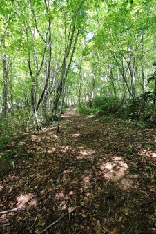
Utasai Beech Forest
Beech trees, the symbol of temperate vegetation, are found in Hokkaido, where pollen analysis has determined that the trees reached what are currently the lowlands of Kuromatsunai almost 680 years ago.
(Photo courtesy of Kuromatsunai Beech Tree Museum)
Blakiston’s Line, the borderline for the distribution of fauna and flora proposed by a British zoologist is famous. This is the theory that the Tsugaru Strait forms the borderline for the distribution of animals and plants, but in the case of plants it is not so accurate. The distribution of temperate vegetation, as typified by the beech tree, spreads to the lowlands of Kuromatsunai and in actual fact this area can be said to be the borderline. To the north and east of the Kuromatsunai lowlands, temperate vegetation gradually disappears and deciduous broad-leafed trees such as beech and Japanese oak become mixed with Sakhalin firs and Sakhalin spruce trees, creating mixed conifer and broadleaf forests.
The wide distribution of these mixed conifer and broadleaf forests is a distinctive feature of Hokkaido’s plant landscapes. Even further north, the ratio of coniferous forests becomes higher, with landscapes similar to those of Sakhalin. What’s more, in Daisetsuzan and Akan, dense primeval forests that remain in their primitive form can be found, which is also a feature typical of Hokkaido.
As Hokkaido is Japan’s northernmost island, there are many flowers that cannot be found on Honshu.
Of the alpine plants, the pretty Yubari-kozakura (Primura yuparensis) of Mt. Yubari, Apoi-azumagiku(Erigeron thunbergii subsp. glabratus var. angustifolius) of Mt. Apoi, and Chishima-gikyo (Campanula chamissonis) and the like found on the Taisetsu Mountains, are famous. The Rebun lady’s slipper orchid (Cypripedium macranthum var. rebunense) and Rebun-usuyuki-so (Leontopodium discolor) are wild orchards that are only found on the island of Rebun. Common glasswort (Salicornia europaea) is a flower that is almost exclusive to the coast of eastern Hokkaido, where it colors the water’s surface red, almost like coral. In the wild flower meadows in the town of Koshimizu, the arrival of the short summer brings with it colorful flowers such as Siberian lilies (Lilium pensylvanicum), Ezokizuge (Hemerocallis flava var. yezoensis), Japanese rose (Rosa rugosa) and the like, which can be seen blooming in unison. The marshes, too, boast an array of distinctive vegetation and in the Kushiro Wetlands, varieties such as Yukiwari-kozakura (Primula modesta var. fauriei), Ezo-ichige (Anemone soyensis) and Ezo osakura-so (Primula jesoana var. jesoana) flower amid the harsh environment.
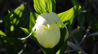
Rebun lady’s slipper orchid (Cypripedium macranthum var. rebunense)
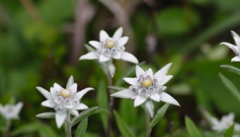
Rebun-usuyuki-so (Leontopodium discolor)
Kuromatsunai Beech Tree Museum
Introducing the history and nature of the town of Kuromatsunai and, in particular, its beech trees. As well as introducing methods of nature observation and information regarding the animals and plants, the museum also features hands-on activity spaces such as wood and ceramic craft workshops, food workshops and the like.
- AddressAza Kuromatsunai 512-1, Kuromatsunai-cho, Suttsu-gun, Hokkaido
- Tel0136-72-4411
- LinkKuromatsunai Beech Tree Museum(In Japanese)
Creatures found in Hokkaido
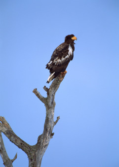
Steller’s sea eagles
With a wingspan of up to 2.5 m, these birds fly in from the Kamchatka Peninsula to spend the winter.
(Photo courtesy of the Shiretoko National Park Nature Center)
The distribution of animals in Hokkaido and Honshu is clearly separated by Blakiston’s Line. Brown bears, Asiatic chipmunks and pikas can only be found in Hokkaido, whereas Asian black bears, wild boars, Japanese monkeys and the like are only found in Honshu. Generally, as seen with the Hokkaido sika deer and Ezo red fox, the animals are conspicuously larger than the varieties found in Honshu.
Weighing between 200 and 300kg, with long, sharp claws and teeth, the agile brown bears are Hokkaido’s strongest animal. The Ezo red fox, with its cute features, is extremely popular but is avoided due to its connection with echinococcosis. In recent years, Hokkaido sika deer have rapidly increased in numbers, and as damage to farm crops is becoming greater, their population management is becoming an issue. The pika is a rare animal that came to Hokkaido from Siberia during the ice age and continues to inhabit alpine areas.
Hokkaido is also the habitat of large birds such as red-crowned cranes, Blakiston’s fish owls, white-tailed sea eagles, woodpeckers and the like. As winter approaches, the cranes leave the wetlands where they rear their young, and head for the feeding grounds in the village of Tsurui to spend winter. With regard to migratory birds, too, every year countless greater white-fronted geese fly in to Miyajima Marsh, and Whooper and Tundra swans arrive at Lake Utonai and Lake Kutcharo. The remote islands provide a number of breeding grounds for seafowl, with Teuri Island boasting a breeding ground of the common murre, which is in danger of extinction.
Dolly varden, Japanese huchen, kokanee and the like are all species of freshwater fish endemic to Hokkaido, and marine creatures such as Steller’s sea lions and earless seals that migrate to the area between the Sea of Okhotsk and eastern Hokkaido’s Pacific coast form part of the Hokkaido’s typical scenery.
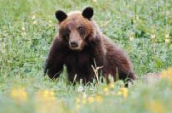
Brown bears
Hokkaido is the only place in Japan inhabited by the brown bear, the nation’s largest land animal. In autumn it eats acorns and crimson glory vine, as well as salmon plucked from the rivers as they return upstream.
(Photo courtesy of Tourism Photo Data/Hokkaido Tourism Organization)
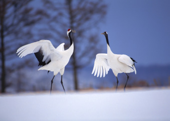
Red-crowned cranes
Approximately 1,300 of these birds inhabit Hokkaido, mainly in the Kushiro and Nemuro regions.
(Photo courtesy of Tourism Photo Data/Hokkaido Tourism Organization)
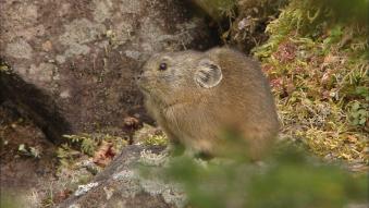
Pikas
An inhabitant of cool rocky crags, mainly over 800 m high, in the Kitami, Taisetsu, Yubari and Hidaka mountains, the pika has a high-pitched cry and its Japanese name means “crying rabbit”.
(Photo courtesy of Shirataki Geopark)
The world natural heritage site Shiretoko, where life is continuous
Shiretoko Goko Lakes
A mecca for Shiretoko tourism with well-maintained trails and boardwalks, frequented by approximately 500,000 tourists annually
(Photo courtesy of the Shiretoko National Park Nature Center)
In 2005, Shiretoko was registered as a world natural heritage site in recognition of the fact that the ecosystem that connects the sea and land can be easily understood; that it is a habitat of many rare animals and plants, including the endangered Blakiston’s fish owl and Shiretoko violet (Viola kitamiana); and that the management system to preserve all these things is seen to be in place.
In Shiretoko the fauna and flora form a variety of ecosystems from the sea to the coastline to the mountains. All of these are preserved in a primeval condition. The plankton nurtured by the ice floes provides nourishment for the fish that become the food of the marine mammals such as seals and birds such as the Steller’s sea eagle. Then, the salmon, nourished by the blessings of the abundant sea, return up the rivers where they help to nurture the animals, such as the brown bears that live there. In this way, all life in Shiretoko is connected.
Shiretoko National Park Nature Center
Located next to the Utoro-Shirietoku Michinoeki (roadside station), this facility introduces the manners required for enjoying the nature of Shiretoko and the national park. Life-size photos of brown bears and Steller’s sea eagles and the like, as well as reproductions of actual marks left by the claws of brown bears on tress, and traces left by birds can also be seen.
- AddressAza Iwaubetsu 531, Oaza Onnebetsu-mura, Shari-cho, Shari-gun
- Tel0152-24-2114
- LinkShiretoko National Park Nature Center
Shiretoko Museum
A wide range of exhibits related to Shiretoko’s nature, geography, history and industry. Events, lectures and exhibitions on various themes are also held.
- AddressHon-machi 49-2, Shari-cho, Shari-gun
- Tel0152-23-1256
- LinkShiretoko Museum(In Japanese)
Rausu Visitor Center
Learn about Shiretoko National Park through explanations, images and exhibits related at its nature, history, culture and use, along with information provided to enable visitors to enjoy the natural environment.
- AddressYunosawa-cho 6-27, Rausu-cho, Menashi-gun
- Tel0153-87-2828
- LinkRausu Visitor Center(In Japanese)
“Geopark” – where the region is a huge museum

Toya Caldera and Usu Volcano Global Geopark boasts 12 footpaths on which the appeal of volcanoes, forests, lakes and the sea can be sensed at close quarters.
(Photo courtesy of Toya Caldera and Usu Volcano Global Geopark)
“Geo” means the Earth or land, and therefore the term Geopark is a park containing places of natural significance viewed from the point of view of earth science. The Global Geoparks Network was established in 2004 with the support of UNESCO, and is made up of natural parks containing important geological, geographical and volcanic heritages recognized in countries throughout the world. Japan has six such recognized regions, and the Toya Caldera and Usu Volcano Global Geopark is one of them.
In addition, a separate Japanese Geoparks Network also exists, and in Hokkaido the four regions of Shirataki, Mikasa, Mt. Apoi and Tokachi Shikaoi are officially recognized. Toya Caldera and Usu Volcano Global Geopark comprises the beautiful natural environment and precious geological features on a grand scale, formed by volcanic activity, as well as numerous remains from the Jomon culture that thrived in the abundant natural surroundings
Geoparks in Hokkaido
Toya Caldera and Usu Volcano Global Geopark
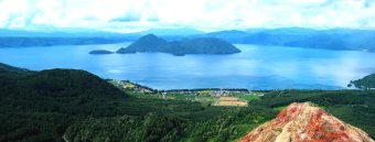
Toya caldera
(Photo courtesy of Toya Caldera and Usu Volcano Global Geopark
As well as many geological and natural heritages, such as Mt. Usu, Showa Shinzan lava dome, Toya caldera and the like, the area also boasts many historical heritages, including the Kitakogane Shell Midden and Kamui Chashi Historical Ainu Park, and it is also popular as a hot-spring resort. Footpaths are established, enabling visitors to see the distinctive natural environment at close hand.
Shirataki Geopark
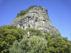
Gumbo Rock
(Photo courtesy of Shirataki Geopark)
- LinkShirataki Geopark(In Japanese)
Mikasa Geopark
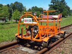
Mikasa Trolley train
(Photo courtesy of Mikasa Geopark)
Sense the traces of life from 100 million years ago, including world-famous ammonites, precious coalmining heritages and the distinctive cultures that took root. The geopark is divided into 5 areas – Katsurazawa, Ikushunbetsu, Ponbetsu, Mikasa, Horonai and Tappuyama – and in the Horonai area, visitors can enjoy riding on a trolley on the remains of the Horonai Railway that was once used to transport coal from the area.
- LinkMikasa Geopark(In Japanese)
Mt. Apoi Geopark

Hidaka-so (Callianthemum miyabeanum)
(Photo courtesy of Mt. Apoi Geopark)
Mt. Apoi was formed by the appearance of peridotite from deep underground, caused by dynamic global-scale fluctuations. Here you can experience the changes in the land that brought with them the unique soil and climatic and geographical environments that nurtured endemic species of fauna and flora such as Hidaka-so (Callianthemum miyabeanum), and Apoi land snails (Paraegista apoiensis), as well as the history and culture of the town of Samani, a trading base since ancient times.
- LinkMt. Apoi Geopark
Tokachi Shikaoi Geopark
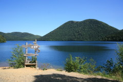
Lake Shikaribetsu
(Photo courtesy of Tokachi Shikaoi Geopark)
Located in the northwestern part of the Tokachi Plain, the geopark covers the entire town of Shikaoi and is the only geopark in Japan with a theme of “ice.” Experience the wisdom of life in a cold region, as well as the geography, ecosystems and industries created by cold and ice. Here, on the land on which pyroclastic flows and volcanic ash accumulated, delicious vegetables and milk are produced.
- LinkTokachi Shikaoi Geopark(In Japanese)